Insights in Mining Science & Technology - Juniper Publishers
Abstract
The study area is in Lokpanta Formation of southern Benue Trough sedimentary terrain, in Abia State. The rocks are believed to have developed in early Cretaceous times and igneous activity was confined to this period in the Benue Trough. Major magmatism in the Mesozoic and Cenozoic formed the hypabyssal and pyroclastic rocks, due to opening of the Trough and its associated tectonism, of this well-defined continental rift setting. The effects of the heat supplied by igneous intrusives can be observed between the host rocks shales and dolerites as metamorphic aureoles, and the other rocks formed are hornfels at Obiulo-Lekwesi area. The petrography of the rocks indicates the phenocrysts minerals like pyroxene 20%, plagioclase 35%, olivine 14% and opaque minerals of Fe-Ti oxides, while quartz is low. The dolerites were emplaced in soft sediments and they are very hard. The rocks are of economic and industrial importance as aggregates for building houses, pavements, bridges, roads and railroad ballast. The mining pits which are several at Lokpaukwu, Lekwesi, Obiulo, Eziama, Lokpanta and Ishiagu areas are open pits filled with large volumes of water. They can be converted to fishing ponds so as to reduce the area from having badland topographical features. Presently, they pose health hazard to animals like cows and goats and even to human beings. The Environmental Impact Assessment (EIA) of the quarries were not carried out before establishing them for the quarrying of the aggregates for pavement and road construction purposes. All the mines surveyed have been abandoned without any remediation or reclamation procedures in place.
Keywords: Dolerites; Average Modal composition; Lokpanta Formation; Benue Trough; SE; Nigeria
Introduction
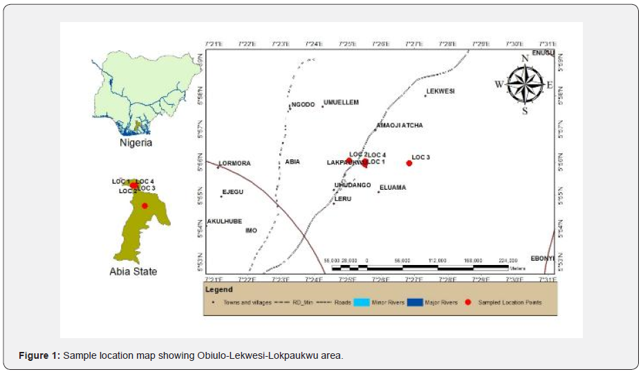
The study area is in Lokpaukwu-Lekwesi-Lokpanta axis located in Abia State southeast Nigeria. Its accessibility is through the Port Harcourt-Enugu dual carriage way and by foot paths or motorcycles. The dolerites are widespread and are emplaced in fracture systems that developed during the separation of Africa from North and South America [1]. The hypabyssal rocks are igneous intrusives which vary from medium-grained to fine-grained, and they are mostly dolerites, diorites, trachytes, unmappable pegmatite and granite-pegmatite rocks. They occurs less than 5m in-situ below the overburden shaly rocks. The initial mining pit locations were identified by the local communities and a major civil engineering firm, Forgerule Construction Company Nigeria Limited, in the 1980’s. They quarried the rocks for aggregates used in pavement construction of the Umuahia – Enugu section, of the 225km Port Harcourt - Enugu dual carriage way. The Figure 1 below indicates the insert Nigerian and Abia state maps, with the sample location map, coordinates Latitude 5° 53' N to 5° 59' N and Longitude 7° 21' E to 7° 31' E showing Leru, Lokpaukwu, Eluama and Lekwesi areas.
Geological Setting
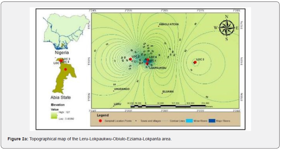
The study area topography is undulating from the highlands of Leru in the south, with the Enugu escarpment running north-south at the western flank while the Abakaliki Anticlinorium is on the right. Figure 2a is the topographic and geological maps of parts of Leru-Lokpaukwu-Lokpanta axis. The shale outcrop covers the entire area and serve as host rock to the igneous intrusives. The area is within the tropical rainforest of southeast Nigeria, with an average rainfall of 1800mm-2050mm per year [2]. The drainage pattern is dendritic, with water flowing from the highlands in the west to east to join River Ikwo in Ishiagu area which flows southeast and joins the Asu River and Cross River drainage basin. The shale supports thick vegetation with trees, grasses, cassava, yams, coco-yams, bananas, plantain and palm trees growing very well. The Eze-Aku Group which forms the sedimentary cover in the study area, has been extensively studied by workers, on the geology of Nigeria in the area like Reyment [3], Amajor [4], Zarbosrki [5] and Ojoh [6], while its tectonism and magmatism has been studied by Ukaegbu [7], Onwualu-John & Ukaegbu [8] and Nwachukwu et al. [9]. The unusually carbonaceous rock in Lokpanta area was first reported by Petters & Ekweozor [10] and Ekweozor & Unomah [11]. However, as more recent data were obtained, they have re-defined the age and depositional environment of Eze-Aku Shale. The fact includes that the shale “black” colour may not necessarily always correlate with high organic matter content associated with sea-bottom anoxia. This was an underlying reason for this recent revision of the stratigraphy of what was hitherto regarded as ‘Eze-Aku Shale’, and the recognition of the ‘Lokpanta Shale’ as a member of the ‘Lokpanta Formation’ has recently been made [12]. The study area falls within Eze-Aku Formation and Lokpanta Formation that is Lokpaukwu and Obiulo-Lekwesi [12] and the geological map of the area modified after, is shown in Figure 2b.
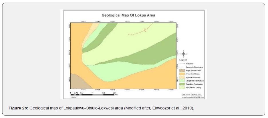
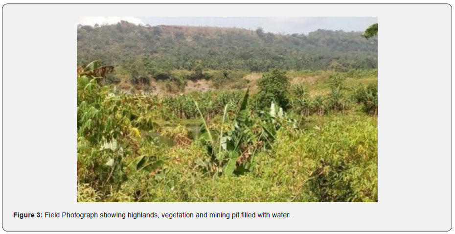
Ekweozor [12] have on the basis of their very extensive geochemical campaign on the profiles of Eze Aku Group units has recently re-defined it. The Lokpanta Formation overlies Lokpanta, Lekwesi, Acha, Ugwueke and Ezeukwu areas; Eze Aku Formation is made up of Lokpaukwu and Aka Eze areas and this two formations form the Eze Aku Group, while parts of Asu River Group can be found at Uturu and Ishiagu areas, Figure 2b is a geological map of the area modified after [12]. The Figure 3 is the field photograph of the area showing the Enugu escarpment highlands running N-S in the west and top of the photograph of the study area and an abandoned open pit mine at Obiulo-Lekwesi area.
Materials and Methods
In this study, all the factors conditioning the exposure of the area was closely made and mapped. The elements of relief, highlands and lowlands was established using topographical map and field investigations as indicated on the field photographs. At the end of the survey, features of all the rocks and indices and names of various intrusive rocks were established and some of the rocks were un-mapable at the scale of the map. The intrusive rocks displayed sharp contact relationships with the host country rocks shale. Thirty rock samples were obtained from the field survey and twenty-five representative sections were sampled for thin sections and petrographical analysis. The observations made include individual grain boundary and dislocation substructure. The average modal composition of the rocks were obtained and compared with previous data obtained elsewhere.
Results and Discussion
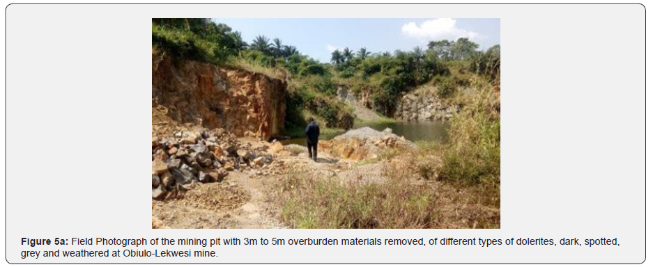
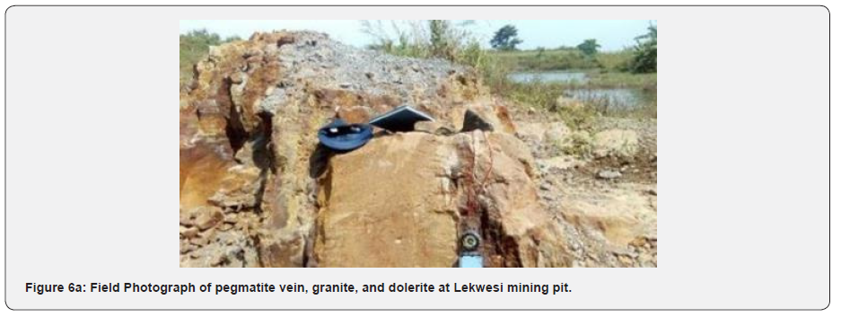
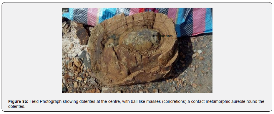
The dolerites (olivine diabase) colour are of different types, dark grey to black or green, some spotted like skin of the leopard when fresh, the grain size is medium-grained, fresh to weathered and there are traces of pegmatite at some sections in the mining pits. This may probably be due to variable ferromagnesian minerals and trace elements composition and weathering profiles of the exposed rocks in the mining pits. The overburden material varies in thickness from one part of the mining pit to another. The deepest part is in the south while the north is shallower. The depth ranges from 3m to 4.5m and the lithology indicates laterite 0.5m, dark shale 2.0m, grey shale 1.5m, bioturbated shale 0.4m and slate/phyllites <0.1m. In some locations, the heat from the igneous intrusions have metamorphosed the shale to slate/phyllites which indicates contact metamorphism and around the rocks, and there are presence of metamorphic aureoles. There is evidence of all the three rock types sedimentary, metamorphic and igneous rocks occurring in the area at various thickness, which can be observed at the locations where local miners mine dolerites at a depth of 1.5m to 3m Figure 4.


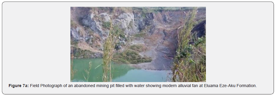
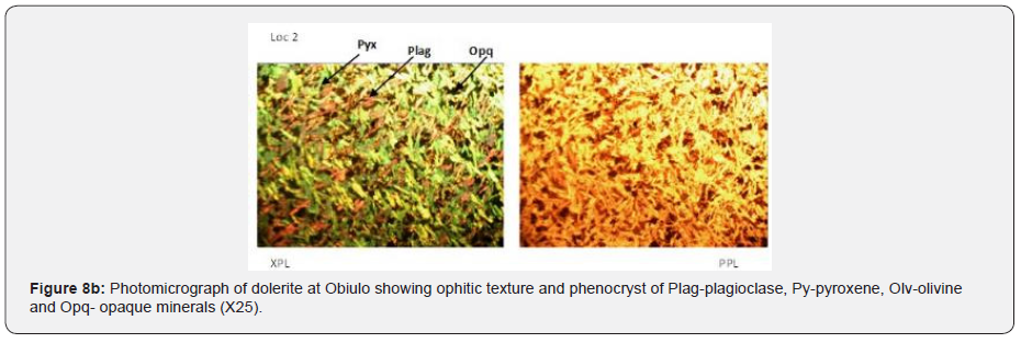
The dolerites texture is ophitic and in hand specimen, can be distinguished from gabbro and it may also be porphyritic. The structure shows vesicles and amygdales occurs. Sometimes it has segregations of coarser rock enriched in feldspar. The mineralogy shows phenocrysts comprise olivine (olivine diabase) and/or pyroxene or plagioclase. The groundmass comprises the same minerals with iron oxide, and sometimes with some quartz, hornblende or biotite. The field relationships are dykes and/or sills. They formed swarms of hundreds or perhaps thousands of individual dykes or sills which often radiate from a single volcanic centre as shown in Figure 4. The filed photographs of the mining pits where the rocks were obtained for thin sections and petrographic studies are shown in (Figures 5-7), while Table 1, is the average modal composition of the rocks analyzed and comparison with similar rocks analysis elsewhere.




Discussion
The Cenozoic volcanism in parts of West Africa is of alkaline affinity [1], while Onwualu-John and Ukaegbu [8] using geochemical evaluation in Southern Benue Trough identified two groups; one having an alkaline affinity and the other with a tholeiitic affinity and contains these minerals ortho-pyroxene, calci-plagioclase and clino-pyroxene. In the Oban massif and Obudu Plateau southeast basement complex areas of Nigeria, the fine to medium grained varieties have been identified with similar characteristics by Ekwueme [13]. Minerals like cordierite, hypersthene, and sillimanite were also identified in the gneisses that are in contact with dolerites in this basement terrain. The Obiulo dolerites are fine- to medium- grained and the fine-grained texture is a reflection of their shallow level emplacement which favoured quick cooling as compared to deep emplacement that will favour slow cooling with texture medium-to coarse-grained. They have ophitic texture and the contact of these dolerites with the host shale rocks are chilled and metamorphosed as shown on the field photographs Figures 4 & 8. Dolerites have been observed as un-mappable exposure along Enyi Boje – Ebok road in meta-sediments and also at Kanyang quarry a granulites environment, in Bansara and Mukuru area with chilled margin and contact metamorphic aureole Egesi [14]. Sholokwu and Egesi [15] and Oyefeso and Egesi [16] also identified minor intrusive rocks; dolerites, charnockites and granites in association with basement rocks migmatites, gneisses and schists in the boundary area between Obudu sheet 291 and Mukuru sheet 305 Table1. In Lekwesi area, Nwokeabia et al. [17] using Vertical Electrical Sounding (VES) and microscopic study identified diorite with mean density 2.88 × 10³ Kg/m³ in an investigation to determine the rocks viability for the establishment of a quarry operation. They observed that the diorite deposit found at the location, is 5.8m thick, while the overburden materials was estimated be 10.49m and concluded that it not economical for large-scale quarrying operations, except for small scale enterprise [18].
Conclusion
The mining pits which are several at Eziama-Lokpaukwu area is in Eze-Aku Formation, while Obiulo-Lekwesi is in Lokpanta Formation and Ishiagu is in the Asu River Group areas have igneous intrusives which are hypabyssal rocks dolerites, microdiorites and diorites, and they ranges from 25m overburden depth in Ugwu-ele mining pit at Uturu area to less than 3m at Obiulo-Lekwesi area. The petrographic analysis indicates mainly dolerites with contact metamorphic auroles and thin section analysis showing the phenocrysts as mainly plagioclase, pyroxene, olivine and minor quartz and opaque minerals and the values of the average modal compositions of the rocks are comparable to the results obtained elsewhere.
To Know more about Insights in Mining Science & Technology
Click here: https://juniperpublishers.com/index.php


No comments:
Post a Comment