Environmental Sciences & Natural Resources - Juniper Publishers
Abstract
Invasive species can negatively influence the environment, economy and human health, so their early detection and monitoring are very important. Traditional field survey methods are being replaced by more efficient, and cheaper methods such as remote sensing methods. The present review summarises different methods for aerial surveys and invasive species on which those are tested.
Keywords: Remote sensing; Invasive species; Drone; Satellite imagery
Introduction
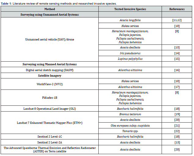
Invasive species pose a considerable threat to biodiversity, and the best way to manage them is through early detection. There are many methods of detection and monitoring the spread of invasive species, and remote sensing methods are promising new approaches and lately intensively tested. The aim of this mini-review is to provide a literature overview of remote sensing methods used so far in invasive species detection, monitoring and management, and respective invasive alien species as case studies (Table 1).

Discussion
Remote sensing (RS) can be defined as information gathering about Earth's surface by using images taken from the air or by using electromagnetic radiation reflected or emitted from the Earth's surface [15]. Remote sensing applications have gained momentum after the development of satellites, drones and technologies that use electromagnetic radiation to create an image of the Earth's surface. Remote sensing technologies, along with Geographic Information System (GIS) and Global Positioning System (GPS) create geospatial data [15]. RS is often used in agriculture [16], archaeology [17], geology, urban planning, wildlife management, and environmental impact assessments [18]. The most used method of RS in environmental biology is the use of UAVs (Unmanned aerial vehicles) known as drones. Nowak et al. [19] present a few examples of the use of UAVs in biology research: applications in wildlife monitoring, population ecology, vegetation dynamics, ecosystem processes and plant conservations. Biological invasions have continuously increased over recent centuries, as well as their impact on biodiversity, economy, and human health [20]. Once established, invasive alien species become very difficult and expensive to detect, map and monitor. Therefore, available and reliable methods for early detection and monitoring the spread of invasive species are crucial. RS methods can serve for faster detection and less resource-intensive monitoring of invasive species in comparison to traditional field methods [21]. Aerial detection of invasive plants can be useful when a particular growth stage (e.g., flowering, ripening) of a plant can be easily identified or for those species with recognizable features [4]. Several authors have discussed the possibility of using different methods of remote sensing in identifying and mapping the presence and spread of invasive species. Joshi et al. [22] concluded that RS methods provide several benefits in the study of invasive species such as synoptic view, multispectral data, multitemporal coverage and profitability. On the other hand, the use of satellite data in the study of invasive species is limited [4]. For example, free available satellite data such as MODIS provide insufficient spatial resolution, while very high-resolution (VHR) satellites like Pleiades, QuickBird, Ikonos, or WorldView are expensive and dependent on the cloud cover at the time of the acquisition. In contrast, Nowak et al. [19] concluded that, MODIS sensors can provide high spectral resolution. Furthermore, Landsat and Sentinel 2 can provide imagery with high spatial but lower spectral and temporal resolution. Manned aeroplanes can be a better option, but they generate high labour and economic effort, and they are not suitable for exploring the smaller areas. UAVs provide low price, high spatial and temporal resolution, do not depend on cloud cover, and are easy to manage but have a short operation time [19]. Alvarez-Taboada et al. [3] suggested that satellite imagery can be used when moderate spatial and temporal resolution is needed, and UAV data for high spatial and temporal resolution outputs.
Conclusion
Remote sensing methods have proven useful in detecting various invasive species, especially for those with recognizable features. Moreover, surveying using unmanned aerial vehicles (UAVs) has proven to be the most perspective method in the detection of invasive species.
To Know more about Environmental Sciences & Natural Resources
Click here: https://juniperpublishers.com/index.php


No comments:
Post a Comment