Civil Engineering Research Journal
Introduction
Expansive soil is defined as partially saturated plastic soil that exhibits high volume change when its environmental conditions are altered from dry to wet. The degree of expansion depends on whether the soil mass contains active day minerals or not. The most common active clay minerals are smectite, sometimes chlorite and vermiculite, and a mixed-layer of smectite and other clay minerals Grim [1] and Sabtan [2]. These soils, which lie above the water table, undergo shrinkage on drying and swelling on wetting. Numerous reports of expansive soil problems and related damages have been documented in different countries [3-5]. A limited amount of these studies was concentrated on developing equations that could be used to predict the swelling potential of expansive clays from their index properties Chen [3]; Abduljauwad et al. [6]; AL-Homoud et al. [4]; Li et al. [7]; Al-Rawas [8]. These studies provide helpful information, which may be applicable to engineering practice.
Expansive soils occur extensively throughout the world and have been reported in numerous countries, including the United States, India, South Africa, China, Romania, Jordan, Saudi Arabia and Egypt Chen [3]; Popescu [9]; Abduljauwad et al. [6], and Abu Seif & El-Shater [5]. In Egypt, expansive soils are found in areas (Aswan, KomOmbo, Edfu, Luxur, Esna, Assiut, Sohag, Assuit Fayuim Suez, Esmaelia, Nasser City, Cairo-Suez Alsphaltic road, Sinai, etc.). This problem is considered as a severe engineering problem in New Valley of Egypt from both design and construction point of view. Buildings on expansive soils may heave, showing movement in a direction opposite to that which one normally expects as a consequence of building loads. Building foundations and semels may be subjected to swelling pressures causing excessive movements and consequently failure. Roads may also heave and differential movements may cause distortion and cracking of pavements. Canal linings, retaining walls and underground structures with expansive soil backfills may be subjected to considerably increased earth pressures with consequent displacement and damage.
In the Dakhla area the Dakhla Formation is a major geological sequence, where it comprises of three known members, from the base to the top are Mawhoob Shale Member, Beris Oyster Mudstone Member and Kharga Shale Member. The three members are comprised predominately especially “Mawhoob Shale Member” of shale with occasionally claystones layers which is the bottom of the Dakhla Formation is weakly compacted, weakly cemented and contains significant amounts of swelling clay minerals. The arid climate and severe weathering environment imposed on Western Desert during its past geological history had a major influence on the wide occurrence of expansive soils in the region (Slater [10]). Gharb El-Mawhoob expansive clayey shales considered as one of the most problematic and least understood geological materials due to the wide variation in the engineering properties. Large areas of Gharb El-MawhoobVilage are covered with Mawhoob Shale Member of which having expansive nature. The swelling and shrinkage potential of these soils caused by mineralogical constitutes. Many buildings in Gharb El-Mawhoob area includes homes, schools, offices which have been damaged by the movements of the superficial expansive clayey soils, because the foundations design has not taken into consideration the expansive properties of these soils (Figure 1).
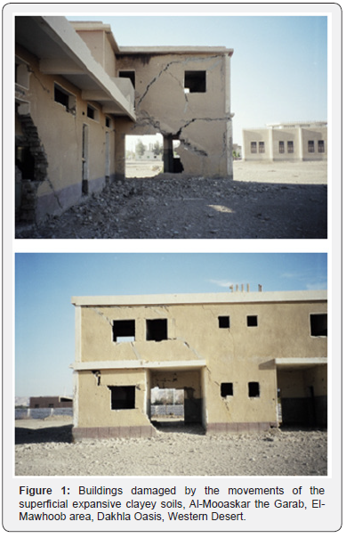
Many investigations in different tropical regions of the world have made considerable research in an effort to recognize the engineering properties and to predict the swelling potential of the expansive soils in their regions. It seems that there is no investigation made on swelling soils in Egypt except the study carried by Youssef et al. [11] on the serious damage caused by swelling to the building of a hospital in Aswan. Superficial clay soil with the potential to shrink or swell with different degree of expansion covers large areas of many cities in New Valley Government such as Garb El-Mawhoob area. The thickness of these superficial deposits varies from few centimeters to more than 12 meters in the above-mentioned areas. These problems include cracking, break-up of pavements, heaving, and damaging building foundations.
This study is part of an effort to lead to improved geotechnical engineering practices by providing the engineering properties of these soils.
Geological Setting of the Studied Area
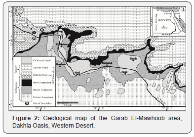
Gharb El Mawhoub area lies on NW of Dakhla Oasis, Western Desert of Egypt. This Oasis is about 490Km west of Assuit (City of the upper Egypt). It is bounded approximately by the latitude 25° 35¯ N, to 26° 00¯ N and longitude 28° 10¯ E, to 28° 54¯ E (Figure 2). The surface geology of the Dakhla Oasis and west Dakhla area have been the subject of a large number of investigations since the last century. Among the most significant are the works of Edmonstone [12], Zittle [13], Hermina et al. [14], Said [15], Abbass &Habib [16], lssawi [17], Mansour [18], Omara et al. [19,20], El-Dawoody & Zidan [21], Mansour et al. [22,23], Askalany [24], Barthel & Herrmann-Degen [25], Bisewski (1982), El-Younsy [26] Luger & Schrank [27], Hermina [28], El-Ezabi & d El-Araby [29] and Tantawi, et al. [30]. The stratigraphic units recognized in the studied area are shown in its geological map (Figure 2). In this region, the upper strata are of Cretaceous age and consist of terrestrial sediments. This deposit, known as Gharb El-Mawhoob Shale Member, the basal member of the Dakhla Shale Formation, which consists mainly of gray shale, graded downward into grayish green shale, green shale, yellowish gray shale and greenish gray shale. These shales have been identified as expansive in nature Holtz &Gibbs [3,31- 34].
Site and Soil Conditions
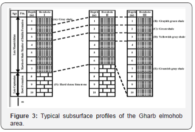
Three boreholes (Sites I, II and III) were drilled in order to obtain undisturbed samples for laboratory testing (Figure 2 & 3). The maximum depth of these boreholes is 10m.The soil profiles of these boreholes showed similar lithologies with variations in depth. Site selection was based on reported structural damages in the area due to expansive soil. The site of boreholes is underlain by a highly expansive soils which considered as a basal part of the Mawhoob Shale Member of Dakhla Formation (Early Maastrichtian age). The Mawhoob Shale Member in the studied boreholes consisting of the top layer (layer A, 1m thick) of hard highly weathered gray shale (layer A), this layer was recorded only in borehole I. This layer is underlain by a 1m thick layer (layer B) of dense grayish green shale. Layer B is underlain by a very dense green shale (layer C, 1m thick). Beneath layer C, the material changes to very hard yellowish gray shale (layer D, 1m thick). or dense dark greenish gray shale (layer E). the thickness of this layer varies from 3m in boreholes I and II to 7m in boreholes III. Layer E is underlain by a very hard dense limestone (Layer F) which reocded only in boreholes I (3m thick) and II (4m thick).
Material and Methods
Representative samples of disturbed and undisturbed soils were obtained at different depths of the above-mentioned boreholes. The undisturbed samples were covered by wax and kept in a cool place until were used in engineering tests (which were done in soil mechanics laboratory in Assuit University). While the remoulded and undisturbed samples were collected from the same depths which were used in others geological tests. The physical and chemical characteristics of the collected samples were investigated to evaluate the main characters of Gharb El-Mawhoob expansive soil. Soil samples were subjected to the following test programs:
I. Determination of physico-chemical properties including organic matter content, carbonate content, pH, cation exchange capacity (CEC) and exchangeable cations.
II. Determination of mineralogical composition by infrared spectral analysis (IR), differential thermal analysis (DTA) and X-ray diffraction (XRD).
III. Determination of geotechnical properties including grading, water content, Atterberg limits and density.
IV. Direct measurements of free swelling, swelling potential, swelling pressure and volume change characteristics.
V. Determination of shearing strength characteristics and consolidation settlement of the studied samples.
VI. Studying microfabrics of the studied samples by using Scanning electron microscopy (SEM).
Physico-Chemical Properties
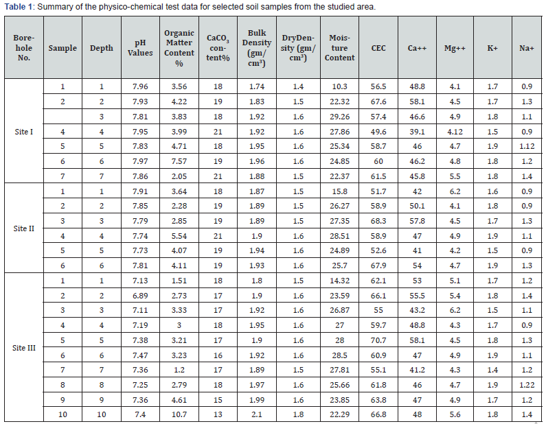
The physico-chemical property indices of studied soils such as total cation exchange capacity (TCEC), type of exchangeable cations, pH, organic matter content (OMC) calcium carbonate content and moisture content are very important for understanding the engineering properties of expansive soil, which are often ignored by soil engineers. CEC and exchangeable cations were determined by atomic absorption spectrum. The physico-chemical indices of soil specimens are summarized in Table 1.
pH values
The pH is equivalent to the common logarithm of the reciprocal of the hydrogen ion concentration in solution. It is responsible for the occurrence of negative charges in soil constituents [35]. The pH dependent charges which occurs in soils is the result of the dissociation of the hydroxyl or carboxyl on the organic matter fraction of the soil or as result of the dissociation of the hydroxyl edges on the clay minerals. Another source of the pH dependent charges in strongly acid soils (pH below 5.5) are the adsorbed aluminum-hydroxyls polymers that are adsorbed on the negative exchange sites. As pH rises, these polymers precipitate out of solution and the exchange sites become free for other cations to be adsorbed iron oxides have a similar effect as the aluminum hydroxy polymers, but the effect can be seen at higher pHs. Swell potential is highly influenced by the exchange complex and to a lesser degree by the pH value especially for the K-clay.
The pH measurements were performed on 1:25 clay-water suspensions using a glass electrode pH-meter. Test results shown in Table 1 indicate the pH value of most Gharb el-Mawhooob soils are above 7 which indicate the alkaline environment of the Gharb el-Mawhooob area.
Exchangeable cations
This is a measure of the type and amount of cations adsorbed into the clay minerals. The amount of exchangeable cations, sodium, calcium, magnesium and potassium were determined using the atomic absorption (flame and lamp photometry) techniques. Table 1 summarizes the exchangeable soil cations of the Gharb el-Mawhooob soil samples. Test results indicate that Gharb el-Mawhooob soils have a greater concentration of calcium and sodium cations than of magnesium and potassium.
Cation exchange capacity
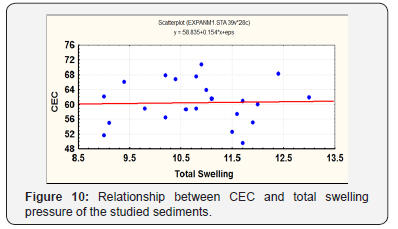
Cation exchange capacity (CEC) has a major significance in determining the properties of clay minerals, particularly the facility by which they adsorb water. CEC is defined by the quantity of exchangeable cations required to balance the charge deficiency of clay and is usually expressed in the mill equivalent of the atomic weight of solvent per 100 grams of soil. The CEC has been determined according to Allen’s procedure [36]. The values vary from 49.6 to 70.7meq/I00g as shown in Table 1, which indicate the presence of expansive clay minerals (smectites).
Organic matter content (OMC)
Organic matter plays an important role in the formation of soil materials. The increase of organic content increases the soil plasticity. Other studies found that the maximum dry density of compaction decreased with increasing organic content whereas the optimum moisture content increased with increasing organic content. With increasing organic content, the plastic limit and the liquid limit of soil increase. The organic matter content (OMC) values of the studied samples varying from 1.2 to 10.65 (Table 1).
Calcium carbonate content
Following Jackson [37] the calcium carbonate content was determined. The calcium carbonate content (CCC) values of the studied samples varying from 13.33 to 21.27 (Table1). There is a general tendency for both liquid limit and plasticity index to decrease with the increase of calcium carbonate content. From relation between water content and calcium carbonate content it is noticed that the water content absorbed from humid atmosphere decreases with the increase of calcium carbonate content. Such result is expected because clay mineral content decreases and consequently amount of adhered water decreases, with the increase of calcium carbonate content.
Moisture content
Representative samples were dried in an oven at 105 °C For about 18hours. After samples had been dried to a constant weight moisture content percent was calculated. The moisture water content of the present studied samples varying from 10.3 to 29 (Table 1). Kassif et al. [38] mentioned that all the structures which rest on, or founded within, particularly saturated clays are prone to damage caused by movement of the soil with changing moisture condition. Uppal & Palit [39] mentioned that swell pressure depends upon the range through which moisture changes. They stated that for accurate assessment of swell pressure, it is necessary to know the extreme variation in the moisture content of the expansive subgrade soil. Brackley [40] concluded that the swell pressure is a function of final moisture content and void ratio. Moafi [41] found that the initial water content had a small effect on the swelling pressure until it reached the shrinkage limit. Higher than the shrinkage limit, the rate of decrease in swelling pressure by increasing water content become quicker.
Mineralogical Identification
The engineering properties of any type of soil are controlled by its mineralogical constituents, especially those comprising the clay fraction. Twenty-three representative clayey soil samples were chosen for mineralogical investigation from the previously mentioned sites These samples were mechanically wet sieved to obtain the less than 63m fraction, then (10- 20gm) was treated with 1M Na OAc buffer solution (pH=5) to remove calcium carbonates and with H2O2 to get rid the organic matter. Finally, the residue was treated with sodium dithonite to remove iron oxides. The suspension was transformed into standard precipitation cylinders. The clay fraction (2m) was separated using standard pipette sedimentation technique.
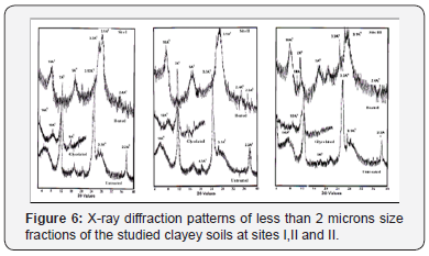
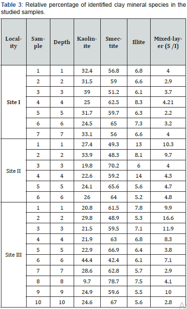
The clay fraction ( 2m) of each sample was divided into three portions: the first portion for IR analysis, the second portion for DTA analysis, and lastly the third portion for XRD analysis. For X-ray diffraction analysis-oriented particles were obtained by careful sedimentation into clean slides. Three slides per sample were prepared: one slide was X-rayed without further post treatment “untreated”. The second was heated to about 550 C for two hours “heated”. The third was placed in an ethylene atmosphere at 60 C over-night “glycolated”. X-ray diffraction (XRD) was performed using Philips Pw 1710 diffactometer. A potential of 40Kv and a current of 55mA were applied on Cu target tube. A nickel filter was used to prevent radiations other than K. The studied samples were scanned between 2 and 40 2 with a speed rate of 1 2 / minute. The obtained X-ray charts were used for the clay mineral identification and quantification. The identification of the clay minerals is based on the basal reflections (001), according to the X-ray powder diffraction results of Weaver [42-43], Carrol [44], Chen [45] and the ASTM cards [46]. Four types of clay minerals were identified throughout the studied sequence, namely kaolinite, smectiteillite, and. smectite-illite mixed-layer (Table 2, and Figure 4).
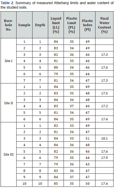
Table 2 summarizes the calculation of the relative amounts of clay minerals in each tested soil sample from the studied area. The calculation was done by considering the integrated intensity of the 17Å glycolated peak area as being equivalent to the relative amount of smectite with minor chlorite. The area of 10 Å (glycolated trace) multiplied by four is equivalent to the relative amount of illite. The 7Å peak area was multiplied by two forthe relative amount of kaolinite with some chlorite (Carrol, 1974).
The presence of smectite indicates that these soils originate from weathered parent igneous rocks. The presence of considerable quantities of smectite is a good indicator of the expansive potential of these soils.
Differential thermal analysis (DTA) of clay fractions of the studied soils show a large endothermic peak at 120 °C which represents the dehydration reaction of clay particles (Figure 5). Variation in size and intensity of the observed peak is attributed to the quantity of water absorbed on the surfaces of layer silicates which has a direct relation to the amount of expansible layer silicates in each fraction and to the total external area exposed by the minerals. The second small endothermic peak at about 575 °C is probably due to the kaolinite dihydroxylation. The third endothermic peak at about 728 °C is due to dehydroxylation of smectite-chlorite minerals. The exothermic peak at about 880 °C is due to the change of phases in clay minerals Mackenzie [47]; Brown, 1988.

Using IR analysis, the structural composition of the clay minerals can be recognized. The diagnostic interlayer Al-O group appears as an intense absorption band (A) in the spectrum range 3695-3445cm-1. From the IR analysis the main groups of clay mineral consisting the kaolinite, smectite, illite, and mixed layer (smectite-illite) were identified without any detailed information about their crystallinity. Finally, results of mineral composition of the clay fraction of the studied sediments, deduced from infrared spectral analysis (IR) and the diffraction thermal analysis (DTA) are in a good agreement with those revealed by and X-ray diffraction analysis (XRD). In addition, each of these analyses was unique in offering information about the characteristics related to every clay mineral species.
Geotechnical Properties
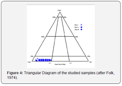
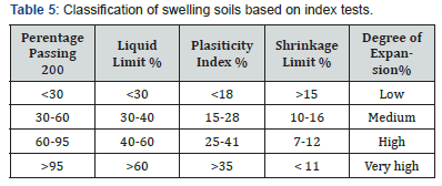
The particle size distribution of the tested soil samples was determined by using both sieves washing analysis and hydrometer analysis. Based on the ternary diagram of it is clear from (Figure 5) that the classes fractions of the studied samples were lied in field of clay indicating a narrow range. Atterberg limits, plasticity index, and water content are shown in Table 2 [48]. Both the Unified Soil Classification System (USCS) and the American Association of State Highway and Transportation Officials (AASHTO) system were used in classification of the tested soils. Accordingly, the studied soil belongs to the CH group of the high plastic inorganic clay in the USCS system and to the A-7-6 group, which is composed of silt and fine clay, in the AASHTO system. Gromko [49], has classified expansive soils based on their index properties as shown in Table 3. According to this classification, the studied soils can be characterized as highly expansive since the values of Atterberg limits for a large number of samples fall within the range of very high expansion Figure 6.
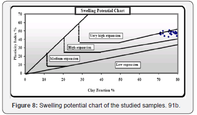
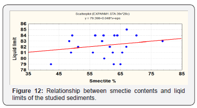
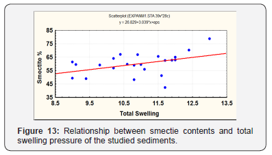
Vijayvergiya & Ghazzaly [32] have proposed a classification on the basis of the plasticity limit and the plasticity index. The Casagrande plasticity chart is divided into two zones by the line-A, with expansive soils above the line and non-expansive soils below it. The studied soil samples were lied above line-A indicating that these samples are expansive ones (Figure 7). Mouroux et al. [50] introduce an additional factor- activity. This is defined as the ratio between the plasticity index and the percentage clayey fraction. With the chart porposed by these authors it is possible to assess the swelling potential on the basis of the activity, the clayey fraction and the plasticity chart index. The studied soil samples were lied in the field of high and very high expansion characteristics (Figure 8). Referring to the results shown in Tables l, 2, 4 and figures (9-13) it can be concluded that there is positive correlation between smectite percentages and values of both of CEC, Atterberg limits and total swelling [51].




Swelling Characteristics
The swelling potential of an expansive soil can be measured directly by: axial free swelling, percentage of swell and swelling pressure tests. These swelling parameters were measured in the laboratory by using the standard one-dimensional odometer apparatus. In this study an additional procedure, based on volume charge measurements under a specified confining pressure, was used to estimate the swelling potential.
Axial free swelling
The free swell test was carried out typically as described by Holtz & Gibbs [31]. The free swell values of the studied samples ranged between 150 and 165 (Table 1).
Swelling pressure test
Swell tests were performed to quantify the amount of vertical swell and swelling pressure. Swelling pressure is equivalent to the external applied load required to return a pre-swelled specimen to its initial volume [52]. The swelling pressure of Gharb El-Mawhoob soil varies from 9.1kg/cm2 to 11.7kg/cm2 (Table 2).
Swell Percent
The swelling percentage is defined as the percentage ratio between the increase in specimen height (ΔH) under a standard stress to the initial height of specimen (Hο). This testing led to a value of swelling percentages ranging from 28% to 37% of the initial volume of the samples (Table 2). Referring to Table 5, it is clear that those samples which have a high percentage of smectite and high values of CEC as well as Atterberg limits show high swelling potential, axial free swelling and swelling pressure, such as sample number 5, borehole 2, location1. Comparison of the swelling potential and swelling pressure of AI-Madinah expansive soils with other expansive soil formations found in the Kingdom indicates that the A1-Madinah soils can be categorized as highly expansive.
Microstructure
As is similar to material composition, the microstructure is also a basic factor that influences soil engineering properties (Push, 1979; Mitchell [53]). Knowledge of the clay mineralogy and fabric can help in developing a better understanding of soil behaviour [54]. Micro-fabric studies in this investigation were carried out using a Philips PSEM-500 scanning electron microscope (SEM) and the procedures followed for the preparation of specimens were as suggested by Smart & Tovey [55]. The micro-fabric characterization scheme developed by Collins & Mc Gown (1983) was adopted for the description of the observed micro-fabric features. More than 15 soil samples that cover expansive soils of the three studied bore holes were subjected to scanning electron microscope (SEM) study. The representative SEM micrographs featuring the expansive soils are shown in Figures (14-21).

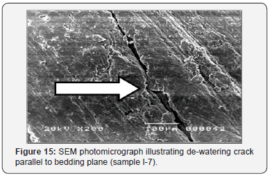
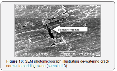
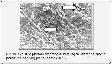
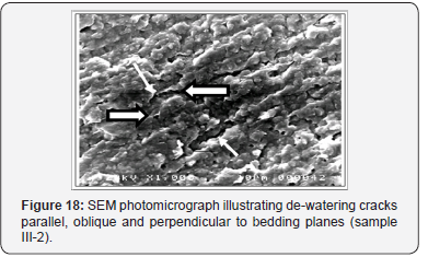
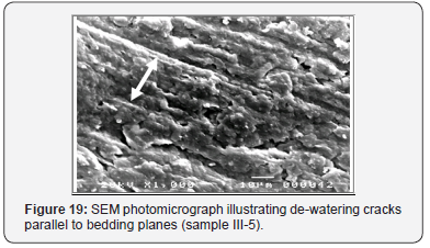
Initially, the surface of each specimen was scanned at low magnification, which reveals the ‘‘general’’ fabric level (Figure 14,15). At this level, the overall character of the fabric is observed, and representative areas are identified. Micrographs were taken at this low magnification. The magnification was then increased which represents the ‘‘intermediate’’ fabric level (Figure16,17). Further, specimens were examined to assess their pore spaces and the orientation of the soil particles. Finally, the magnification was increased from which represents the ‘‘clay particle’’ fabric level. Micrographs were taken at this level within the representative areas identified earlier. The form of clay particle interaction and the distribution of interparticle pores were carefully examined at this level (Figure 18-19).
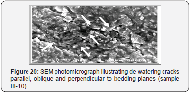
The SEM of the studied samples indicated that the fabric of the samples generally consists of dense clay matrices, although clay–granular matrices were observed occasionally (Figure 8-21). In addition, no connectors were observed and only a few aggregations were seen. At the general fabric level (Figure 14,15), the sample fabric consists of very uniform matrices with few pore spaces apparent. At the intermediate level, the matrices are composed mainly of dense clay matrices (Figure16,17). The basic pore spaces are mainly of an intra-assemblage type. At the clay particle fabric level as shown surround clay matrices contain a system of clay particles that have a random distribution. Intraassemblage and intra-elemental pore spaces are observed at this level. The appearance of the sample suggests a relatively strong degree of preferred orientation in the phyllosilicates. This is best seen in the relatively low-magnification photographs of sections oriented perpendicular to bedding (Figure 14,20).
The SEM micrographs especially those of parallel sections show dominantly clayey size grained fabrics in which coarser grains (sand-sized grains are negligible but silt-sized grains were seen). The SEM micrographs of the studied samples especially those of perpendicular sections show flocculation and aggregation that clearly seen in the directions of cracks which due to de-watering. These cracks are parallel, oblique and perpendicular to bedding planes (Figure 14-20).
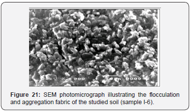
Comparison shows that there are relatively more planar faces of the platy minerals visible on the sections oriented parallel to bedding (Figure 8-9). Although there is a significant degree of preferred orientation in the views taken at high magnification, the orientation can be seen to be far from perfect in both perpendicular and parallel sections. Nevertheless, the preferred orientation is sufficiently strong to suggest that it may account for the unusual engineering properties of the normally consolidated clays. From the SEM images especially, which taken at high level of magnification it is clear that the dominant micro-fabrics of the studied sediment are of flocculation and aggregation type (Figure 20,21).
Flocculation and aggregation have major effects on engineering properties. Aggregation increases the viscosity, but not much. Flocculated causes a high yield stress and a high viscosity. Flocculation thus makes the soil very stiff and difficult to work. When particles are flocculated, liquids move relatively easily, and permeability is increased. Dispersion, on the other hand, reduces permeability. Particles tend to plug small pores and impede water flow. Flocculation also increases shear strength and reduces compressibility [53-71].
To Know More About Civil Engineering Research Journal Please click on:


No comments:
Post a Comment